


 Coastal Geology (Hawaii)
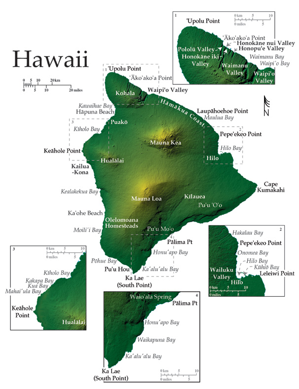
The Island of Hawai‘i lies over or just north of the Hawaiian hot spot and is composed of five volcanoes and one active seamount: Kohala, Hualälai, Mauna Loa, Kïlauea, Mauna Kea and Loihi located offshore. Of these, only Mauna Loa, Kïlauea, and Loihi are considered active, while Haulälai is dormant with its most recent eruption ending sometime in 1800-1801. The island has 428 km of general coastline and is so large relative to the other Hawaiian islands, it is known locally and abroad as the Big Island.
On the Big Island, well-developed black and green sand beaches signify the active reworking, by waves and currents, of the freshest lavas in the state. The island’s youth has, in general, allowed for a lower degree of beach formation along its rough volcanic coastline. White calcareous beaches make up a relatively small component of the shoreline largely because of poor reef development due to recent active coastal volcanism.
The orographic effect of the Big Island’s large shields: Mauna Loa (4,169 m), Mauna Kea (4,205 m), and Kohala (1,670 m) create a lush region on the northeast side of the Big Island, where annual rainfall is 150–400 cm.
The Puna District comprises the eastern most corner of the Big Island, reaching out at Cape Kumakahi, a broad rocky point with a shallow slope at the coast. This area was resurfaced during the 1960 flow originating from Kïlauea’s east rift zone. The flow narrowly missed the navigational light on the point as it remarkably divided into streams and flowed around the lighthouse (Clark, 2002).
North of Cape Kumukahi the coast extends for roughly 25 km around Leleiwi Pt. into the Hilo District and Hilo Bay in a series of wave weathered low rocky sea cliffs, and rough remnant lava flows . Hilo Bay is one of two deep draft harbors on the Big Island. The bay is the seaward end of the Wailuku River valley that runs along the junction between the younger Mauna Loa lavas to the south and older Mauna Kea lavas to the north. A breakwater 3 km long extends offshore from a large natural deep water gap in the fringing reef of Kühiö Bay. The structure runs west in front of the developments fronting eastern and central Hilo Bay. Hilo is a heavily populated coastal city that was devastated in both 1949 and 1960 by tsunamis originating as earthquakes in the Aleutian trench and along the Chilean coast respectively (Fletcher et al. 2002). In 1984 Mauna Loa broke a nine-year period of quiescence sending lava flowing down to the northern city limits, a reminder of the volcanic hazard in this coastal city (Fletcher et al. 2002).
The Pepe‘ekeo-Hämäkua Coast stretches for 100 km between Hilo and Waipi‘o Valley to the north. This northeast and northern exposed coastline consists of a steep rocky shoreline of Mauna Kea lavas, characterized by a multitude of headlands, sea cliffs (~30-90 m high), coves, and irregular embayments such as: Onomea, Hakalau, and Maulua bays. The Hämäkua coastal embayments are seaward ends of stream carved gulches that originate upland on the lush Mauna Kea mountainside, and are a passage to the coast for water rich with sediment, soil, and eroded volcanic rock. Black volcanic pebble and cobble stone beaches line the bay heads, and large blocks of fluvially transported basaltic debris along the shoreline lie where they have been scattered by high-energy waves. No fringing reef has developed along this relatively young shoreline, however offshore rocky islets are commonplace along the northeast coasts of the Big Island; totally exposed to north Pacific trade wind seas.
Waipi‘o Valley, in the far northeast, marks the junction where Mauna Kea lavas to the south overlie lavas of the broad and elliptical Kohala Volcano (1,670 m) to the north. Kohala is the Big Island’s oldest shield, projecting northwestward and forming the northernmost portion of the island. Waipi‘o Valley is the first, and most immense (approximately 1 km wide), of seven spectacular shore-normal amphitheater valleys that extend northwest along the Kohala coast. These valleys developed during a lower stand of the sea (~90 m), and were partly filled with alluvium at that time. As sea level rose the alluvium was reworked and the modern low lying, scenic wetland valley floors that lie inland of the coast were created (Macdonald et al. 1986).
The valleys, such as: Waimanu, Honopu‘e, Honokäne Nui/Iki and Pololü, are bordered by steeply ascending massive rock walls. Except for a four-wheel drive road into Waipi‘o, access to the lush valley floors is limited to foot trails or boats. Dynamic beaches dominated by black volcanic sand, line the seaward end of the northeast Kohala valleys. Between the largest of the amphitheater valleys, the coast is dominated by blunt sea cliffs that rise to 400 m above the ocean, the truncated remains of the shield that once extended at least a kilometer into the ocean. The cliffs are incised by numerous stream cut canyons 300-750 m deep that form a series of narrow coastal hanging valleys (Macdonald et al. 1986). This area represents the only coastal segment of Kohala that was spared resurfacing by the Hawi Volcanic Series toward the end of the Kohala main shield building stage when Hawi lavas flowed over most of the eroding shield (Macdonald et al. 1986).
North of Pololü Valley, the east Kohala coastline is made up of steep lava headlands and irregular low lying rocky embayments where streams enter the ocean out of wetland gulches. Like the shoreline to the south, small rocky sea stacks lie offshore of eastern Kohala, isolated from the retreating coast by heavy North Pacific surf (Fletcher et al. 2002). This coastal morphology, with the addition of sparsely distributed cobble and boulder beaches, extends from the exposed northern tip of the island at ‘Upolu Pt. around to Kawaihae Bay and Harbor at the western intersection of the Kohala and Mauna Kea shields.
The western side of the Big Island lies in the lee of Mauna Loa (4,205 m), the largest volcano on Earth (measuring from the sea floor), which has formed in the last 600,000-1,000,000 yrs, rising almost 9 km from the sea floor. The leeward climate is extraordinarily dry with 25 cm annual rainfall, and minimal stream erosion on the Hawi lavas of western Kohala, and on the lavas of Mauna Kea, Mauna Loa, and Hualälai, south along the coast respectively. Kawaihae Harbor is the second deep draft harbor on the Big Island and is fronted by a system of offshore fringing reefs. Several sand beaches exist at the south end of Kawaihae Bay, derived from eroded coral that was dredged during construction of the harbor.
Approximately 5 km south of Kawaihae, along a shoreline of bright golf course greens and hotel development, lies Häpuna Beach, the widest of the few well-developed calcareous sand beaches on the Big Island. The Puakö coast, lies just south of Häpuna Beach, along the coast that was extended by historic Mauna Loa eruptions. Renowned for its tide pools at the shoreline and well-developed offshore fringing reef, the Puakö coast is a popular scuba dive destination.
Hualälai Volcano (2,521 m) makes up the central western coast of the Big Island. Now a dormant volcano, it last erupted in 1800–1801, burying an ancient Hawaiian village along the northwest coast. From the western banks of the shallow coastal lagoon at Kïholo Bay, the Hualälai coast extends southwest and is rocky and shallow sloped. Offshore fringing reef and pocket sandy beaches line the numerous embayments including: Kakapa, Kua, and Mahai‘ula Bays along this coast.
Lavas of the most recent Hualälai eruptions make up the coast from the south side of Mahai‘ula Bay to the western tip of the island at Keähole Pt. This shoreline is characterized by low rocky headlands fronted by fringing reef, small rocky remnants offshore, and beautiful tide pools and beaches (both black and white) along the shore. The coastline of historic Hualälai lava extends less than 30 km south of Keähole Pt., beyond Kailua-Kona to the small non-distinct west facing Kuamo‘o Pt. Lavas of the southwest Mauna Loa rift zone extend beyond Kuamo‘o Pt. to the south point of the island. The South Kona district has a coastline rich with relics of historic Hawaiian habitation. Much of this coast is low-lying historic lava that has been gradually invaded by hardy vegetation. In contrast, Kealakekua Bay is an area along this coast that contains steep cliff walls that reveal the layered nature of their basalt. The bay is accessable only by boat or foot trail and harbors one of the State’s underwater parks. This 315-acre marine conservation district is lined with a vibrant healthy reef ecosystem (Clark 2002). Abundant fish swim about the shallow corals that dip steeply away from shore toward deeper water. The bay is the location where Captain Cook moored for reprovisioning, and ultimately his death.
Between Ka‘ohe and Moili‘i, streaks of relatively recent flows (1950’s) extend to the coast from the volcano. Here tide pools at the shoreline are generally formed of lava spits in various stages of erosion. These areas are mainly accesable by 4x4 roads and are devoid of development.
Because of its relative youth, the Mauna Loa coastal terrace of the southwest coast has lower degrees of soil development. In its absence, subsurface streams fed by upland precipitation penetrate the relatively young porous basalt. These conditions have created a system of sub-surface fresh water flows that feed wetlands and offshore freshwater seeps along southwest coast of the Big Island from Miloli‘i to Ka lae Pt. The shoreline from Moili‘i to Ka lae Pt. is made up of shallow and moderately sloped headlands and low sea cliffs, and is backed by numerous wetlands areas fed by the underground freshwater flows. Beaches of the southwest coast are almost exclusively black sand. Several cones of cinder and ash lie just inland of the southwest shore and were built by littoral explosions during historic sea entries of Mauna Loa lavas (Macdonald et al. 1986). The most recent flows of 1868 produced Pu‘u hou a cinder cone rising 72 m from the shoreline. Wave erosion has truncated the cone, resulting in a beach of red cinder at its base. Olivine sand beaches skirt the rocky headland coasts of south Hawai‘i produced by the fresh erosion of the island’s basalt.
Extending north from Ke lae Pt. the southeast coast is made up of steep rocky headlands that transition to a low-lying coastal plain in the region of Honu‘apo Bay. This geologically complicated area has been impacted by historic tsunamis and general tectonic subsidence. The Kïlauea southwest rift zone cuts through the coastline into the seafloor several kilometers northeast of Waio‘ala Spring, at Pälima Pt. marking the end of the wetland areas of south Mauna Loa and signaling the start of the Kïlauea coastline.
Kïlauea Volcano is a large bulge on the southeast flanks of Mauna Loa although it is an independent volcano with its own magma plumbing system. This volcano has been consistently active since at least the early nineteenth century, if not since its emergence above sea level, continuously creating and redefining the coastal areas along east and southeast sides of the Big Island. On
May 12 th 2002, the Mother’s Day Flow, commenced on the south flank of Kïlauea after issuing from a new vent near the southwest base of Pu‘u ‘ö‘ö cone, 8 km upslope from the south east coast. As is typical of Kïlauea flows, the Mother’s Day Flow travels as molten lava through preexisting lava tubes down the south flank of the volcano to the coastal plains. By late July 2002, two arms of the flow had reached the ocean, forming a broad lava delta that runs 570 m along the coast extending 50 m offshore of the West Highcastle coast, and a 1,540 feet wide lava bench that extends more then 300 ft offshore at Wilipea. Lava benches, such as at Wilipea, are a mechanism of island growth. These form as lava builds up repeatedly into thick and wide benches at the coast. Lava benches may collapse suddenly into the ocean, leaving behind sharp cliffs, and creating steam plumes of lava haze as seawater boils and vaporizes on contact with the rocks that may be hotter then 1100º C. These collapses may release water vapor, sulfur dioxide, chlorine gas, and fine shards of volcanic glass. Activity at the surface of Kïlauea reflects the dynamics at depth within the magma chamber that are recognized as earthquakes on the surface. They may mark movement of the south flank, as it shifts steadily seaward at a rate of about 8-10 cm per year (Morgen et al. 1998).
Coastal Areas Report, Page & Photo Credits:
University of Hawaii Manoa
School of Ocean & Earth Science and Technology
Images Reproduced by Permission of USGS: Series 1-2761
